Breach of Faith:
By Wendell Cox,
INTRODUCTION Like many other urban areas in the United States, Charlotte faces challenges in controlling traffic congestion and air pollution. In an attempt to address this problem, local officials placed a public transit sales tax measure on the ballot in 1998, based upon the adopted 2025 Plan. , The voters of Charlotte-Mecklenburg approved a new sales tax for this long term transit development plan that featured the development of five transit corridors that would utilize light rail and rapid bus transit. The 70 mile, $760 million capital plan was characterized by planners as “helping the region to meet federal air quality requirements…”[1] and “reducing the total vehicle miles traveled in the region…” [2] Since that time, local transportation agencies have worked to begin implementing some of the improvements in the 2025 Plan., Optimism is high. Charlotte Area Transit System (CATS) general manager Ron Tober has expressed the hope that transit’s market share will increase markedly in the years to come: I think we will be successful here in Charlotte with 15 to
20 percent (using public transportation). I think we now have 2 to 3 percent.[3]
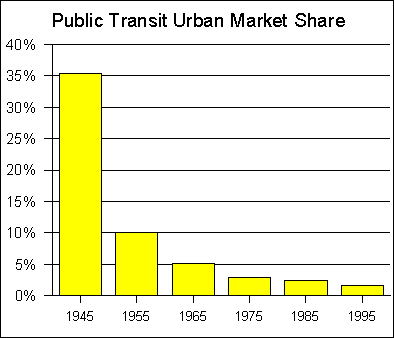
This report analyzes current plans for development of the first corridor under the 2025 Plan, the South Corridor Light Rail Line and describes its impact on the balance of the system contained in the plan. TRANSIT: US BACKGROUNDTransit Since World War IIAt the end of World War II, approximately 35 percent of urban travel was by public transit. Immediately after the War, transit began losing market share to the automobile at a significant rate. By the time subsidies became widespread (1970), transit’s share of urban travel had fallen to 3.6 percent. Subsidies have since climbed to more than $20 billion annually, yet transit’s share of urban trips has fallen to 1.8 percent (Figure #1).[4]
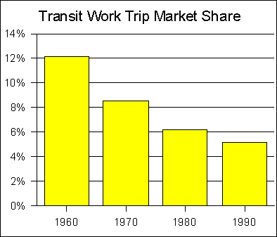
Figure 1 Public transit has sustained its greatest market share loss among riders who have access to automobiles. From 1960 to 1990, the public transit work trip market share has declined by more than 50 percent (Figure #2).[5] As a result, transit’s dominant purpose has become mobility for low income and disabled citizens. In 1995, approximately 70 percent of transit riders did not have automobiles available for their trips.[6] In Charlotte, the figure is higher, with 87 percent of riders not having automobiles available for their trips.[7]
Figure 2 In virtually every metropolitan area in the nation, the overwhelming majority of travel is by personal vehicles (automobiles and light trucks). Among the metropolitan areas with more than one million residents in 1990, the work trip market share of the automobile was from 63 percent to 93 percent, with only the New York metropolitan area below 79 percent.[8] Transit's market share exceeds that of the automobile in only a handful of cases, such as for commutes to six of the nation's largest downtown areas (New York, Chicago Brooklyn, Boston, San Francisco and Washington). But even in these urban areas, transit carries a comparatively small percentage of commuters to employment areas outside downtown. In other cities, transit carries such a small market share that it generally has miniscule impact on traffic congestion. Light Rail and Traffic Congestion: The RecordFor some time, urban traffic congestion has been increasing. Despite transit’s small market share, there has been the hope, if not the expectation, that transit can play an important role in reducing traffic congestion. Light rail has been invoked by a number of interests as a principal strategy in the battle against traffic congestion. Moreover, since automobiles produce a significant share of air pollution, it is anticipated that encouraging drivers to use transit will have positive air quality benefits. Unlike heavy rail (subway, elevated or metro) systems, which are 100 percent grade separated, light rail generally operates at grade.[9] Light rail is a contemporary name for the “streetcars” or “trams” that operated in most large US cities from the late 19th century to the 1950s and 1960s. Electric power is collected from overhead lines. Because it operates generally at grade, light rail tends to be considerably slower than subways and automobiles.[10] Light rail can carry up to 15,000 to 25,000 riders per hour in each direction in trains of up to three cars. Examples of light rail include the St. Louis Metrolink, Portland’s MAX and the Los Angeles “Blue Line.”[11] The person carrying capacity of a single freeway lane is approximately 2,750. As a result of their high theoretical person carrying capacities, light rail systems are often suggested as an effective alternative to building more highway capacity. But, in fact, light rail usage is only a fraction of the theoretical capacities. Highly regarded systems in Portland, Dallas and St. Louis, which are among the most heavily traveled systems in the nation carry fewer than 2,000 riders per peak hour in the peak direction.[12] Generally, one-half or more of the light rail riders formerly rode bus services that were replaced by the rail service. The new ridership attracted to light rail from freeways is in fact quite small compared to the carrying capacity of a single freeway lane. The average freeway lane in US metropolitan areas that have built new light rail systems (since 1980) carries four times as many people per mile as light rail. Even signalized surface streets average twice as many people per mile as light rail. There are a number of reasons why light rail fails to live up to the traffic reduction claims of its proponents. The most important are that: The modern metropolitan area is far too dispersed in
residential and employment locations for any mass transit facility to be able to
remove a significant percentage of drivers from automobiles. Generally, transit
is able to provide service that competes in time and convenience with the
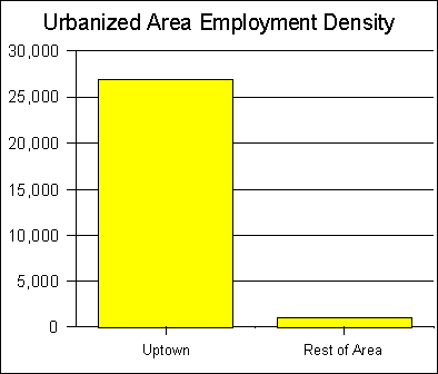
automobile only to a single downtown area in each metropolitan area. Light rail has a particular disadvantage in travel time. On average, during peak travel periods, light rail operates only slightly faster than buses[13] and barely one-half as fast as automobiles.[14] Overall transit market shares are very small. Only in the New York metropolitan area is market share higher than five percent. In most metropolitan areas, transit carries less than 1.0 percent of travel.[15] With such a small market share, even a doubling of transit ridership would have virtually no impact on traffic congestion. These realities are routinely confirmed in urban rail feasibility studies, which generally show neither perceivable traffic congestion relief nor air quality benefits from building light rail systems. CHARLOTTE: BACKGROUNDDemographicsPopulation and GrowthCharlotte is now the 32nd largest metropolitan area in the nation, with a 1999 population of 1,417,000. Charlotte is also one of the fastest growing metropolitan areas. From 1990 to 1999, the metropolitan area grew 22 percent, ranking 8th among the 49 metropolitan areas with more than 1,000,000 population (Table B-1, Appendix B).[16] Charlotte is also the largest metropolitan area in North Carolina. The core Mecklenburg County (also referred to as “Charlotte-Mecklenburg”) had a population of 648,400 in 1998, up 26.8 percent from 1990. Population DensityThe core of the Charlotte metropolitan area is the city of Charlotte and Mecklenburg County (Charlotte-Mecklenburg), which includes seven counties and 3,379 square miles of land area in North Carolina and South Carolina.[17] Despite being a metropolitan region, the overall population density is low, at 409 persons per square mile.[18] By comparison, five states are more dense,[19] and two (New Jersey and Delaware) are more than twice as densely populated as the Charlotte metropolitan area. The entire nation of the Netherlands, with vast expanses of agricultural land is also more than twice as dense, with at nearly 1,000 persons per square mile. Mecklenburg County, at 527 square miles, is considerably more dense than the balance of the metropolitan area, at 1,230 residents per square mile. This is a relatively low density for the core of a metropolitan area, and somewhat higher than the state of New Jersey and the Netherlands US metropolitan areas are defined using county boundaries,[20] rather than the limits of urban development. Because there is considerable variation in the size of counties across the nation, comparisons of metropolitan area population densities are misleading.[21] The urbanized (developed) area: A more appropriate measure of urban density is the US Census Bureau’s “urbanized areas,”[22] which are defined by adjacent urban development. In 1990, the Charlotte urbanized area contained 455,000 residents, 65th in the nation. This is considerably lower than the Charlotte metropolitan area’s 1990 ranking of 34th. The urbanized area covered 242 square miles, with a population density of 1,880 per square mile. Among the 41 metropolitan areas with more than 1,000,000 residents in 1990, Charlotte ranked 40th in the percentage of residents in the core urbanized area,[23] at 39.2 percent (Table B-2, Appendix B). Only Greensboro-Winston-Salem-High Point ranked lower, at 18.6 percent. By comparison, the average core urbanized area accounted for 74.6 percent of its metropolitan area population. In addition to ranking next-to-last, the Charlotte urbanized area (and Greensboro-Winston-Salem-High Point to an even greater extent) was well outside the range of the non-North Carolina metropolitan areas, 11 percentage points behind 39th ranking Hartford and 17 percentage points behind 38th ranking San Francisco. Moreover, the Charlotte urbanized area was very sparsely populated, at 37 percent below the average of the 41 areas. Only the Kansas City urbanized area, with nearly three times the population was less densely populated than the Charlotte urbanized area. At the same time, North Carolina is one of the nation’s more populous states, ranking 11th in 1998, with more than 7.5 million residents. Since 1990, North Carolina has added more than one million residents, more than all but five states. But the distribution of population in North Carolina is more dispersed than in the other large states. Except for North Carolina, all of the 11 largest states had much larger urbanized areas. In eight of the other 10 states, the largest urbanized area ranked among the nation’s top 10. Outside of North Carolina, Ohio’s largest urbanized area ranked the lowest (Cleveland), at 21st. In contrast, (as noted above), North Carolina’s largest urbanized area, Charlotte, ranks 65th. This suggests that Charlotte, and for that matter North Carolina metropolitan areas[24] are considerably different from those in the other large states. In each of the North Carolina metropolitan areas, much more of the metropolitan population lives outside the core urbanized area. North Carolina metropolitan areas are not only typified by comparatively low urbanized area densities, but the population tends to be more widely dispersed outside the core urbanized areas. The North Carolina metropolitan areas, such as Charlotte, experienced their greatest population growth after World War II, and thus do not have the large, dense residential or commercial cores that are typical of older metropolitan areas. As such, Charlotte and the other North Carolina areas represent the purest form yet developed of contemporary metropolitan structure. EmploymentCharlotte’s growth has been accompanied by strong employment growth. Charlotte has emerged as one of the world’s leading banking centers. As in the case of virtually all US metropolitan areas, most employment growth has been outside the central business district. Nonetheless, Charlotte’s business growth has produced a central business district (“Uptown”) with some of the nation’s tallest skyscrapers. In 1990, Uptown contained 10.8 percent of the metropolitan area’s employment.[25] Uptown was by far the most dense employment center in the area, at approximately 25 times the density of the balance of the urbanized area (Figure #3).[26] However, with approximately 50,000 jobs, Uptown Charlotte is small compared to national metropolitan standards. At least 25 metropolitan areas have downtown areas with more than 100,000 jobs.[27]
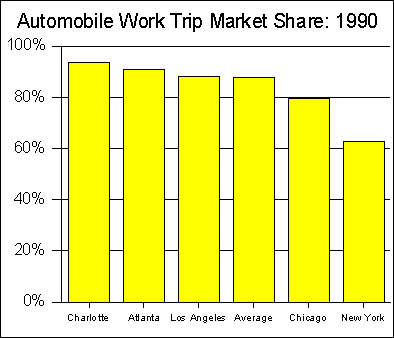
Figure 3 TransportationTraffic CongestionAs in all major urban areas, there is concern about traffic in the Charlotte area. Nonetheless, Federal Highway Administration data indicates that Charlotte has been comparatively successful in accommodating its growing traffic. From 1982 to 1997, Charlotte’s Roadway Congestion Index (RCI) dropped 3.7 percent, from 1.08 to 1.04.[28] Charlotte, along with Houston are the only urbanized areas that experienced a reduced RCI over the period. This does not mean, however, that traffic congestion is non-existent in the Charlotte area. Average work trip travel times are increasing. From 1980 to 1990, average travel time increased from 19.9 minutes to 21.6 for the work trip.[29] Nonetheless, Charlotte’s average work trip travel time remained somewhat below the major metropolitan 25.2 figure. [30] Charlotte is comparatively dependent upon the automobile. In 1990, Charlotte had the highest private vehicle (automobile and light truck) work trip market share of any US metropolitan area over one million population, at 93.3 percent (Figure #4).[31]
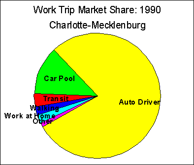
Figure 4 Transit In 1990, public transit accounted for 1.7 percent of work trips in metropolitan Charlotte. This is a 35 percent market share decline from the 1980 figure of 2.6 percent. In Charlotte-Mecklenburg, transit’s work trip market share was higher, at 3.4 percent, down 31 percent from the 1980 figure of 4.9 percent. Walking and working at home combined, at 4.3 percent, accounted for more work trips than public transit in Charlotte-Mecklenburg (Figure #5).[32]
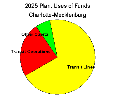
Figure 5 Charlotte-Mecklenburg’s largest employment center is the central business district (CBD), Uptown., Uptown has the largest transit work trip market share in the area, at 10.4 percent. Even so, automobiles carried nearly eight times as many commuters to Uptown (83.8 percent).[33] Transit commuters to downtown had an average income at least 20 percent below that of the metropolitan area average in 1990. Outside downtown, transit commuters earn less than one-half the metropolitan average.[34] This suggests that a many downtown transit commuters and many more non-downtown transit commuters do not have access to automobiles. The 2025 Plan In 1998, the voters of Charlotte-Mecklenburg approved the 2025 Plan, composed of transit improvements intended to reduce traffic congestion and air pollution. Generally, the 2025 Plan called for development of what was referred to as five rapid transit corridors and improved express bus service (light rail is generally not rapid transit)[35]. Light rail was to be built in the north and south corridors. Express busways were to be built in the Independence Avenue, University and Airport corridors. Busway service was to be provided in the North Corridor, in addition to light rail. The 2025 Plan was to cost $1.085 billion over 25 years, including $760 million for building transit lines (bus rapid transit and light rail), $71,million in other capital costs and $254 million in operating costs for expanded bus service (Figure #6).[36]
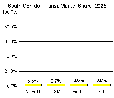
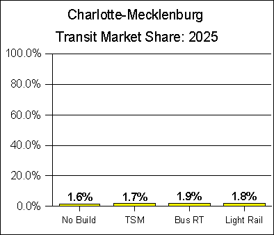
Figure 6 The 2025 Plan assumed that land use planning in Charlotte-Mecklenburg would be significantly altered to improve the operation of the transit system. More residential and commercial development would be established within the five transit corridors (within one-half mile of stations),[37] while lower densities would be sought in the “wedges” between the corridors. In the intervening months, the Metropolitan Transit Commission (MTC) has been established and planning for transit construction has proceeded. THE SOUTH CORRIDOR The first transit line to be subjected to detailed planning is in the South Corridor, from Uptown to Pineville. CATS and MTC have produced a Major Investment Study[38] that reviewed alternative routes and service strategies. The MIS generally found the Norfolk Southern rail right of way to be the most desirable. The most important service strategies were: A light rail line that would be augmented by feeder buses. A bus rapid transit system. These alternatives were compared to a “No Build” Alternative, which projected impacts if all of the other four transit corridors were build, but not the South Corridor. The Light Rail Alternative Based upon the 2025 Plan, a light rail line is proposed in the South Corridor. This represents the first of five corridors that would be developed under the 2025 Plan. A Major Investment Study has been published,[39] which outlines an alternatives analysis that included different alignments and technology options (bus and light rail). The light rail line from Uptown to Pineville has emerged as the “locally preferred alternative,” which is being submitted to the federal government for funding approval. Ridership The MIS projects daily ridership in the South Corridor under the Light Rail Alternative at 15,800 in 2025. It is projected that overall CATS ridership in Charlotte-Mecklenburg would rise from a projected 90,000 daily passenger trips under the No Build Alternative[40] to 101,200 by 2025.[41] Typically, new light rail systems attract one-half or more of their ridership from existing bus riders.[42] However, unlike other communities that have built light rail, Charlotte does not have a strong bus ridership base to feed light rail. Indeed, light rail systems alone in San Diego, Los Angeles, Portland and St. Louis carry more daily riders than the entire Charlotte transit system. In each of these urban areas, light rail represents no more than a third of transit system ridership. Data in the MIS further indicates that the transit system would attract approximately 11,200 projected new riders daily (riders who do not presently use transit) as a result of the South Corridor Light Rail Line. However, only 50 percent of the ridership increase would occur in the light rail corridor.[43] While the South Corridor Light Rail Line ridership figures (5,600 new daily riders) themselves appear to be reasonable, it seems implausible that the corridor improvements would generate such a significant ridership increase outside the corridor. It would be more likely that there would be little or no attributable increase outside the corridor. As a result, it is estimated that the new ridership attributable to the project would be no more than 6,000. Transit Market ShareAccording to the MIS, the South Corridor Light Rail Line would increase transit’s market share in the South Corridor, from 2.2 percent to 3.5 percent, a rise of 1.3 percentage points (Figure #7).[44] Within Charlotte-Mecklenburg, the South Corridor Light Rail Line would increase transit’s share of trips 0.2 percentage points, from 1.6 percent to 1.8 percent (Figure #8).[45] The Bus Rapid Transit Alternative, which would achieve the highest ridership of any strategy studied, would add another 0.1 percentage points in the South Corridor and would attract the same market share as the Light Rail Alternative throughout Charlotte-Mecklenburg. Thus, even if the ridership projected by the MIS is achieved, the increase in transit’s market share will be very small, whether in the South Corridor or in all of Charlotte-Mecklenburg.
Figure 7
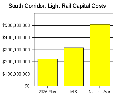
Figure 8 Capital CostsThe capital cost for the South Corridor Light Rail Line is projected at $331.1 million .[46] This compares to the South Corridor Light Rail Line projected cost as contained in the 2025 Plan of $227 million (1998$). Since the 1998 election, the cost of this line has increased 33.5 percent ($88 million), excluding inflation related costs. The Charlotte Area Transit System federal “New Starts Report,” misleadingly indicates that the constant 1999 dollar cost is $254 million, attributing the widely reported cost increase to $331 million as being due to inflation. CATS breakdown of that cost increase which is included as Appendix C, indicates that only $16 million of the $77.1 million increase is attributable to inflation. In interviews General Manager Ron Tober has attributed the cost increases not to inflation but to design and construction management, which the “initial figure didn’t include.”[47] However, the 2025 plan specifically indicates these cost are included; "The total cost also includes design and construction administration/management fees, and a contingency to account for the conceptual level of engineering and to allow for unknowns (30 percent for most items)."[48] The South Corridor Major Investment Study which was completed in Spring 2000 also indicates these costs are included in its $254 million capital cost projection; "Capital costs are in 1999 dollars and reflect all components of costs including design, construction, vehicles, right-of-way, and estimated contingencies."[49] CATS documents also indicate that a 10 percent contingency has also been added. This is in addition to the 30 percent construction contingency that was included in the 2025 Plan. MTC/CATS uses the erroneous $254 million dollar number to calculate cost per new rider that is a critical number in the Federal Transit Administration analysis process. The choice of light rail in the south corridor over bus rapid transit and HOV lanes was based on the lower $254 million figure which produces a more favorable comparison. In fact, the $77 million cost increase was not announced until the Charlotte City Council, the Mecklenburg County Commission and the MTC had chosen light rail as the preferred option. Since the cost of the light rail option has increased none of the above bodies have reviewed their choice of light rail in the South Corridor as the preferred option with its now much higher cost that threatens the viability of transit in the other corridors. An actual failure to include design and construction management in the 2025 Plam and Major Investment Study would represent a serious oversight in the preparation of these reports and would call into question the competence and validity of the entire process. [50] The conflicting and erroneous explanations for these cost increases is equally troublesome and seriously damages the credibility of MTC and its General Manager. The misreporting of these cost increases to the Federal Transit Administration demonstrates how far Charlotte and many communities will apparently go to obtain federal dollars for their local projects. This rate of cost escalation, is approximately 15 percent per year. Such a rate is not unusual for projects in the planning stage. Among light rail projects in planning for which federal funds were being sought in 1999 and 2000, average annual costs rose 21.0 percent.[51] But more importantly, regardless of the real reasons for the higher current projected capital cost of the South Corridor Light Rail Line, it is well below that of similar projects in planning around the nation. The South Corridor Light Rail Line is planned to be 11 miles in length, with an average cost per mile of $29 million. Among the 14 similar light rail projects for which federal funding was being sought in 1999 or 2000, the average cost per mile is $46.3 million,[52] more than 60 percent more than the projected cost of the South Corridor Light Rail Line. Only two of the of the 14 projects in planning are projected to cost less than $40 million. Ten of the 19 projects are projected to generally cost in the $40 million to $50 million range.[53] At the national average, the South Corridor Light Rail Line would cost $509 million, $282 million more than originally forecast. CATS General Manager Ron Tober seems to recognize the potential volatility of present cost projections: Once the engineering phase is complete in fall 2002, we will then get good cost estimates …[54] Based upon the 2025 Plan cost projections submitted to the voters, this would create funding shortage of $282 million for the first of the five transit corridors (Figure #9).[55] Such an overrun would reduce funding for the other four corridors, which were to have cost $533 million according to the 2025 Plan, by nearly one-half.
Figure 9 Cost overruns of this magnitude are
not unusual in such projects. A
National Academy of Sciences report evaluated the international experience in
transportation system projections (such as fixed guideways) and found:[56] ... the main
lessons are that cost overruns of 50 to 100 percent are common for large
transportation infrastructure projects: overruns above 100 percent are not
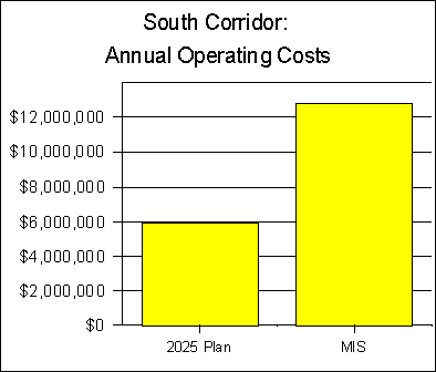
unusual. Consistent with the international findings, the United States Department of Transportation found that urban rail systems averaged cost overruns of 46 percent in a 1989 report.[57] Operating CostsThe South Corridor Light Rail Line is projected to cost $12.8 annually to operate compared to the No Build Alternative. This represents a substantial increase in relation to the operating cost contained in the 2025 Plan. That prior projection placed annual operating costs at $5.9 million (Figure #10).[58] In the less than two years since the voters approved the 2025 Plan, operating costs for the South Corridor Light Rail Line have escalated 118 percent. This would create a funding shortfall of $6.9 million annually relative to the 2025 Plan, which would amount to approximately $136 million through 2025.[59]
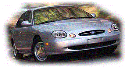
Figure 10 . Cost Escalation Based upon MTC projections, the present capital and operating cost overrun through 2025 (compared to the 2025 Plan) amounts to $226 million (approximately $88 million in capital costs plus $138 million in operating costs). However, the cost overrun is likely to be significantly higher, based upon the national experience. At the national average, a capital cost overrun of $282 million would occur, raising the overall cost overrun to $440 million ($282 million capital cost overrun plus $138 million operating cost overrun). Whether the MIS cost escalation or that predicted herein occurs, it seems clear that the transit system promised the voters under the 2025 Plan cannot be delivered with the available revenue. Cost per New PassengerThe New Starts Report and MIS[60] indicates that the cost per new one-way ride would be $10.76. The recent escalation of capital costs to $315 million as discussed above would raise the cost per new one-way ride to $12.39. The annual cost per new commuter (person using transit to and from work every day) would thus be $5,575.[61] This is not a one-time cost. It is a cost that would be incurred every year for every new commuter. The same amount of money could lease each new commuter a Ford Taurus or similar car in perpetuity (Figure #11).
Figure 11 Annual Cost per New Commuter per
MIS Equals Lease Rate for a New Ford
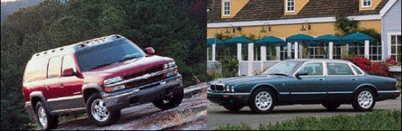
Taurus However, as indicated above, it is likely that capital costs will be much higher than projected, and project ridership is likely to be much lower. If the light rail line costs $509 million and the number of new riders is 6,000 (instead of 11,200), as projected above, the cost per new one-way ride would increase to $37.22, or $16,749 annually. This is enough to lease each new commuter a Jaguar XJ8 and a Chevrolet Suburban in perpetuity. Over a 40 year career, the cost would be approximately $670,000. (Figure #12).
Figure 12 Annual Cost per New Commuter
More Likely to Equal Lease Rate for a New
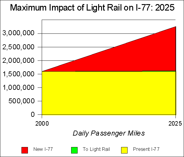
Chevrolet Suburban and a Jaguar XJ8. Impact on TrafficThe MIS does not provide specific projections with respect to the impact on traffic congestion of the South Corridor Light Rail Line. It is clear, however, that little impact is expected. As was noted above, the MIS projects a somewhat small 0.2 percentage point increase in transit’s share of trips in Charlotte-Mecklenburg and a 1.3 percentage point increase in the South Corridor. Even if all of transit’s market share increase were to come from automobiles, this level of modal shift would be imperceivable. The insignificance of light rail’s impact on congestion is illustrated by applying all of the transit ridership increase to the adjacent Interstate 77. If all of the new travel on transit as a result of the South Corridor Light Rail Line were taken from I-77, a 0.5 percent reduction in traffic would occur (Figure #13). Over the same period, the number of new cars added to the freeway would be 300 times the number diverted to light rail.[62] Of course, the small amount of passenger demand transferred from automobiles to the South Corridor Light Rail Line will be dispersed throughout the entire south corridor street and freeway network, so that the impact will be even less perceivable than shown in the figure below.
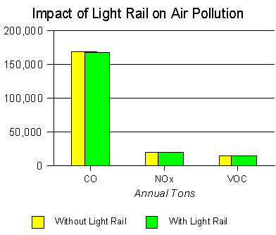
Figure 13 Chart enlarged to make “To Light Rail” visible. Impact on Air PollutionAccording to the MIS, the South Corridor Light Rail Line would have “no significant impact” on air pollution. This is a reasonable conclusion, in light of the miniscule traffic impact projected by the MIS. Indeed, the New Starts Report indicates that the reduction in each of the three “criteria pollutants” would be less than 0.3 percent (Table #1 and Figure #14).[63]
Figure 14 Speed The South Corridor Light Rail Line is not likely to be particularly attractive as an alternative to automobile commuting because of its slow operating speed. With multiple grade crossings, it is likely to operate at well below average automobile speeds in the corridor. Impact on Development Light rail is often promoted as a mechanism of urban development. The expectation is that light rail will
concentrate development, thereby reshaping the city into spatial patterns that
reduce automobile dependency, while generating more favorable traffic and
access. For example the Portland’s planners anticipated that light rail would
result in a “reurbanization” of the corridor, causing a rapid conversion to
high density uses in the light rail corridor, a reduction in the growth rate
outside the corridor, a reduction in automobile use and ownership, among other
impacts.[64] In fact, nothing of the sort has occurred.
Light rail development has been heavily subsidized (below), growth continues to
be focused in outlying areas, not along the light rail corridor, and automobile
usage has continued to increase at a far greater rate than transit use (above).[65] Light rail’s development impacts are somewhat more problematic. Light rail has generally not produced
development, much less reshaped cities. The majority of development cited by
light rail promoters has been either government projects or tax subsidized.
Portland and St. Louis have built publicly financed sports facilities
(stadiums) and convention centers (as have
cities without light rail, such as Detroit, Charlotte, Seattle and
Minneapolis). Portland’s transit oriented residential developments have
received tax subsidies and tax abatements. And, the city of Portland now grants
10 years of property tax abatement for developments within walking distance of
light rail stations. Tax and subsidy policy, not light rail, is the driver of
such development. If higher densities of develop should occur
adjacent to light rail lines, it will make traffic and air pollution worse, not
better. This is because the overwhelming majority of trips to new developments
will continue to be by automobile. This is illustrated by Atlanta’s Midtown.
Midtown’s can be classified as transit oriented commercial development, and is
served by MARTA’s metro system. Yet this transit oriented development, largely
built since the metro system opened, has produced greater traffic congestion,
not less. Recent research indicates that more than 90 percent of commuters to
this growing employment center commute by automobile, instead of transit .[66] Virtually the same problem exists with
respect to transit oriented residential development. For example, the transit
oriented development around the Ballston, Virginia (Washington, DC) subway
station is five times as dense as neighboring communities, and generates four
times as many vehicle trips per acre.[67] Not only is traffic congestion worsened
around the transit oriented development, but air pollution is an order of
magnitude worse, because of the inevitably slower average speed of vehicles in
the area (below). Any significant new commercial and residential development along light
rail lines will increase both traffic congestion and air pollution. The
overwhelming majority of travel will continued to be by automobile and that
travel will be concentrated in a smaller area if rail generates significant
development. If transit were able to “reshape” cities, then it would have already
occurred in Washington and Atlanta. In these two urban areas, nearly $15
billion has been spent to build expensive heavy rail systems that radiate from
the downtown areas. Because of their higher operating speeds and the number of
lines that have been built, the development that they have encouraged is far
greater than could be expected from the slower and less comprehensive light
rail systems, such as is proposed in Charlotte. At a few suburban stations
there has been office and residential construction. But work trip market shares
at these locations is far lower than in the historic downtown areas (the case
of Atlanta’s Mid Town was described above), as the overwhelming percentage of
commuting to the new jobs has been by automobile. As a result, traffic congestion throughout the Washington and
Atlanta urbanized areas has become among the worst in the nation.[68] Perhaps the most aggressive land use impact claims have been made with
respect to the Dallas light rail system One transit system commissioned study[69]
found that light rail has led to higher property values in Dallas and compared
what it considered to be comparable areas along the light rail lines and in
non-light rail areas. There are, however, problems with this study: Some of the properties evaluated in the Dallas
analysis are not within walking distance of a light rail station (the study
uses the transit standard walking distance of 1/4 mile). The light rail/non-light rail comparison
areas listed in the study do not appear to be comparable. For example, the
non-light rail areas do not include any significant office centers that are
comparable to the office centers along the North Central Expressway (which is
also the route of the light rail line). There are numerous other examples of
commercial property that could have been included. The study uses a very small sample of
properties, such that exclusion of single properties from the analysis can have
significant impact on the overall results. Most important, the study fails to factor
out the impact of rebuilding and expanding the North Central Expressway, which
is also the route of the northern segment of the light rail line. The study
simply assumes that all added value is the result of light rail. It would be
expected that the North Central Expressway, which in its expanded portions
along the light rail line will carry many more people than light rail, would
have dominant impact on property values in comparison to light rail. [70] Finally, in Dallas, as in Denver, Chicago, Seattle and other cities,
there is a resurgence of inner city development that is occurring in many
areas, not just areas located adjacent to rail lines. Why Selected The South Corridor Light Rail Line has been adopted as the locally preferred alternative based upon “quality of life considerations.” These include lower noise and pollution levels relative to Bus Rapid Transit. The most important reason, however, was the anticipation that light rail would generate significant development. As was noted above, market based (non-subsidized, private) development has generally not occurred adjacent to light rail lines. The MIS does not consider the potential negative impact on the quality of life due to the higher levels of localized traffic congestion and air pollution that the 2025 Plan implies would occur if significantly higher density development occurs. The Bus Rapid Transit AlternativeDescription The MIS also evaluated a Bus Rapid Transit system that would operate in the same corridor as the proposed South Corridor Light Rail Line.
Ridership The MIS projects the BRT daily ridership at 16,600, slightly more than the 15,400 daily trips on South Corridor Light Rail Line. This CATS/MTC projection undermines the misperception that discretionary riders (those with automobiles available for their trip) are as inclined to ride buses as rail where similar service quality is provided. It further reaffirms federal research indicating that there is no inherent market preference for rail over bus.[71] The impact on the overall transit system, however, is more significant, with daily ridership rising 13,800 from the “no build” scenario, compared to the 11,200 increase projected for the South Corridor Light Rail Line (Figures #7 and #*). Capital Costs The BRT alternative is projected to require capital costs of $166,1 million. This is approximately $155 million less than the cost of the South Corridor Light Rail Line. Even so, this BTR capital cost is 44 percent above that projected for the South Corridor bus rapid transit alternative reviewed in the 2025 Plan, which was to have cost $115.1 million. This 44 percent cost escalation is more than three times the cost increase associated with the light rail alternative in the same corridor. The original capital cost estimate converted to $10.5 million per mile, itself 12 percent above the $9.4 million national average of bus rapid transit systems in planning.[72] The MIS cost projection converts to $15.1 million, 71 percent above the national average. It appears, as a result, that the capital costs of the Bus Rapid Transit system could be significantly overstated. Operating Costs The BRT is projected to cost $14.2 million more annually to operate than the No-Build Alternative. This is $1.4 annually more than the incremental operating cost projection for the South Corridor Light Rail Line. In contrast to capital costs, the 2025 Plan did not project a bus rapid transit operating cost in the South Corridor. However, the MIS projected annual operating cost exceeds by 24 percent the combined projected operating cost of all four other busway corridors that are identified in the 2025 Plan University, Independence Avenue and Airport). The Bus Rapid Transit Alternative is so expensive to operate that it would cost more than one-half the present operating cost of the entire Charlotte transit system. The operating costs for the Bus Rapid Transit Alternative appear to be implausibly high. Potential Planning Bias Former Southern California Rapid Transit District (Los Angeles) Controller Thomas A. Rubin has recently recounted a number of strategies used by planning agencies that have pre-selected rail alternatives as opposed to bus rapid transit alternatives. He refers to this practice as the “butchers thumb on the scale.”[73] The inexplicably higher operating and capital cost escalation of the South Corridor bus rapid transit alternative in relation to the light rail alternative could be such an instance. The Bus Alternative Could Deliver on 2025 Plan Promises The Bus Rapid Transit Alternative would perform only marginally better in attracting new transit ridership. However, the already apparent cost escalation of the light rail line threatens the ability to deliver the five transit corridors in the 2025 Plan system (below). Even with the bus rapid transit system cost escalation, it is well within the budget for the South Corridor as presented in the 2025 Plan. In light of the impact on the overall program, the selection of the expensive and escalating South Corridor Light Rail Line as the preferred alternative is problematic. Such a decision could be reflective of a bias for light rail regardless of its cost or impact (Table #2).[74]
It should be noted, however that while the BRT alternative would increase transit ridership more than the South Corridor Light Rail Line, the incremental increase is very small in relation to traffic volumes. Like the South Corridor Light Rail Line, the BRT would have no perceivable impact on traffic congestion and no significant impact on air pollution. Like light rail, BRT is not likely to have a significant impact on development in the corridor. THE 2025 PLAN This section will analyze the 2025 Plan in general, and in particular, impact of the South Corridor Light Rail Line on the 2025 Plan. The 2025 Plan, which was approved by the voters of Charlotte-Mecklenburg, promised the development of five transit corridors (North, University, Independence Avenue, South and Airport). As noted above, three of the routes were to be busways, one light rail (South) and one was to use diesel powered rail cars (North). The North corridor was also to be served by a busway. The overall capital cost of this program was to be $760 million Capital CostsThe total capital cost for the five corridors was to be $760 million, according to the 2025 Plan approved by the voters. But it seems apparent that this capital cost projection is now considerably low. The cost of the South Corridor Light Rail Line has already
escalated $88 million in cost from $227 million the 2025 Plan to $315
million. It is likely that this line could experience cost escalation, of $282
million more than projected in the 2025 Plan (above), based upon the
national average for similar projects in planning. The North Corridor DMU (diesel multiple unit) rail line[75] was projected in the 2025 Plan to cost $165 million, or $7.2 million per mile for the 23 mile route. This is considerably below the national average of DMU rail projects in planning ($16.9 million).[76] Further, no DMU rail line has been built in the United States for decades. As a result of this lack of experience, cost projections are less likely to be accurate. The DMU rail average cost could actually be higher once projects are built. At the national average, the North Corridor DMU rail line could cost $223 million more than projected in the 2025 Plan ($389 million). The rejected South Corridor BRT has escalated in cost 44 percent compared to its cost in the 2025 Plan. If this same rate of increase, the other three busways would add $164 million to the costs projected in the 2025 Plan. The South Corridor light rail and North Corridor DMU rail lines could consume more in capital costs than the $760 originally projected for all five corridors. At the present national average, the two lines alone would require $898 million to complete, in excess of $126 million above the projections placed before the voters for the five corridor system. To make matters worse, there is now a proposal for a “temporary” 23 mile commuter rail line to be built in the North Corridor for $. This line was not included in the 2025 Plan, and its construction would further reduce the already slim prospects for delivery of the five transit corridors, especially if cost escalation occurs. MTC projects[77] that the line will cost $52 million to build, or less than $2.3 million per mile. In contrast, the average new commuter rail line in the United States has been $4.4 million. [78] Thus, if the newly proposed commuter rail line costs the national average to build, a cost overrun of approximately $50 million would occur.
Uncertain Funding The 2025 Plan assumes that Charlotte-Mecklenburg will be able to obtain 25 percent of the required funding for the plan from the state government and 50 percent from the federal government. The balance of 25 percent would be obtained from the transit tax that was approved by the voters. These represent very aggressive assumptions. There is not currently a state funding source that would provide the level of support anticipated. In addition, the 50 percent federal funding assumption could turn out to be optimistic. As is the case with any federal funding, there is intense competition among jurisdictions throughout the nation. And, technical merits are not necessarily the driving factor --- politics can be more important. For example, Sioux City, Iowa, the nation’s 221st largest metropolitan area, has received a Congressional “earmark” for funding to build a light rail line. Operating Costs There are a number of indications that operating costs will be much higher than projected in the 2025 Plan. As was noted above, incremental operating costs for the South Corridor light rail line have increased over 118, indicating the likelihood of $136 million higher costs through 2025. Application of the same factor to the North rail line would add another $209 million to operating costs through 2025.[80] Moreover, the 2025 Plan assumes that bus unit operating costs (cost per hour) will remain within inflation over the next 25 years. Yet, over the past two decades, Charlotte transit system bus costs per hour have risen substantially ahead of inflation. From 1979 to 1998[81], transit costs rose 35.2 percent per vehicle hour, or 1.60 percent per year (inflation adjusted). Continuation of the same performance through 2025 would raise costs approximately $395 million more than assumed in the 2025 Plan. This is consistent with the already noted much higher projected operating costs under the Bus Rapid Transit Alternative. Indeed, costs have risen so significantly at Charlotte Area Transit since 1998, that the operating cost projected for 2025 (1998$), with all five transit corridors operating will be reached in 2001, without operating any of the corridors. CAT has projected 2001 costs that are the equivalent of $46 million in 2001, the same figure as was used in the 2025 Plan for 2025 operations. [82] The most significant cost increase has been in administration, which is up more than 400 percent. This an extraordinary increase, especially in a city (Charlotte) that has prided itself in limited the growth of bureaucracy and costs during the 1990s. From 1994 to 2000 non-public safety city staff declined while population increased approximately 20 percent.[83]
Moreover, the recently released 10 year projections show that operating cost inflation will continued at a brisk pace. It is projected that 2010 transit system operating costs will be approximately $130 million. This figure, which is $95 million in 1998 dollars is more than double the $46.0 million total operating cost projected for 2025 in the 2025 Plan. Further, it should be noted that higher service levels and additional transit corridors are to be completed by 2025, which would indicate an even greater operating cost overrun. Based upon this early performance,
operating costs in excess of 2025 Plan projections could exceed $1.1
billion through 2025.[84]
It is projected that operating costs would be $1.375 billion (1998$), compared
to the $254 million projected in the 2025 Plan. Responding to the 2025 Plan Deficit Various strategies have been used by transit agencies to use current resources to cover shortfalls in transit corridor development. Replacement of bus fleets has been postponed, which has the disadvantage of raising maintenance costs and making buses less comfortable. Higher than necessary bus fare increases and bus service reductions have been implemented, though this has become a less attractive strategy since a resulting Los Angeles civil rights suit has effectively stopped construction of that area’s rail system. Each of these strategies is punitive toward present transit riders and tends, in the longer run, to make transit systems weaker in their mobility providing role. Other transit agencies have provided much lower levels of bus feeder service. This is one of the reasons that light rail systems have failed to meet their ridership projections. Charlotte would have limited alternatives for delivering the 2025 Plan consistent with present plans and operating procedures: Canceling development of some corridors. Further tax increases Bus fare increases and service cuts The most promising strategies for balancing the 2025 Plan financial program would be to cancel transit corridors and limit future bus service expansions. This would leave east Charlotte and west Charlotte without transit corridors, while inordinately burdening the low income riders who depend primarily on bus service. With respect to the transit corridors, Charlotte could be well on the way to canceling nearly one-half of its planned system, as has previously occurred in Los Angeles, Dallas and St. Louis, where post tax increase cost escalation left transit systems a only shadow of their intended size. This could raise civil rights and discrimination issues. The present state of the 2025 Plan could lead to a Los Angeles-like situation in which Charlotte-Mecklenburg’s low income communities could seek redress for unfair treatment. The basis for such an action could be any bus fare increase or service reduction, or failure to build transit corridors that would serve low income areas. Despite the significant cost escalation that has occurred with respect to the 2025 Plan, there may be an opportunity to deliver on its promises, by building lower cost busways, converting transit operations to competitive contracting and paring back escalating administrative costs. Busway Corridors It would appear that the promised five corridors can only be provided within the voter approved budget only if all five are built as busways. The 2025 Plan projections for all five corridors as Bus Rapid Transit was $547 million. Even if costs escalated at the same rate the MIS projects for BRT in the south corridor, the five corridors could be built for $747 million, slightly below the promised $760 million (Table #4).
Competitive Contracting of Bus Operations Data in the MIS indicates that operating costs will be far higher than forecast in the 2025 Plan. There is the potential to significantly reduce unit operating costs (costs per hour or mile) through the use of competitive incentives. Around the world, major transit systems have and are being converted to competitive contracting, under which the transit agency maintains full policy control of the system, while awarding limited time contracts for the operation of routes or segments of the system. Fares, route alignments, timetables and service standards are established by the transit agency, which administers contracts to ensure that adequate performance is achieved. Both bus and rail service have been competitively contracted. In each of these cases, the transit system remains an integrated whole, and customers are largely unaware of the fact that the system is provided by multiple operators. For example: London has competitively contracted the world’s largest bus
transportation system, with over 6,000 vehicles. The conversion took place over
a 15 year period, and resulted in a 42 percent reduction in costs per mile
(inflation adjusted). Overall operating costs have fallen 26 percent (inflation
adjusted), while service levels have been expanded 28 percent. Ridership has
risen 10 percent.[85] Stockholm has competitively contracted all of its bus, metro
(heavy rail), light rail and commuter rail services. Cost savings per mile have
been 20 percent,[86] with a
conversion period over less than 10 years. Ridership is up 10 percent.[87] Other examples of conversion to competitive contracting are
other metropolitan areas throughout Sweden (such as Gothenburg and Malmo),
Copenhagen, all metropolitan areas in New Zealand, Perth and Adelaide. South
Africa is preparing for a national conversion.[88] In the United States, progress toward
competitive contracting has been much more modest, in large part due to special
federal labor provisions for transit employees, and the absence of mandates
that would have required costs to be maintained at competitive rates. However,
there are important success stories:[89] In San Diego, a gradual competitive contracting conversion
of the bus system has been underway for 20 years. By 1999, approximately 43
percent of bus service was competitively contracted. From 1979 to 1998, costs
per vehicle hour of operation declined 42 percent (inflation adjusted). At the
same time, bus ridership has increased more than 50 percent. [90] During the 1990s, fast growing Las Vegas has established a
new public transit bus system, which is 100 percent competitively contracted.
Costs per vehicle hour were $36.89 in 1998, 32 percent below CATS bus costs. In contrast to San Diego’s 42 percent cost reduction, CAT’s bus costs per vehicle hour rose 35 percent (inflation adjusted) from 1979 to 1998 (Figure #15).[91] An attrition based (no-layoff) competitive contracting strategy, following the San Diego and Las Vegas examples, could reduce costs relative to the 2025 Plan by nearly $125 million.[92] This would represent a more than $500 million reduction in the financial requirement for bus operations if CATS costs continue to rise at the historic rate ($395 million, as noted above, plus $125 million).
Figure 15 Delivery of the five transit corridors as busways and competitive contracting could make it possible to deliver on the promises of the 2025 Plan. A sizeable amount (estimated at $136 million) could be available to finance additional capital cost escalation, if necessary (Table #5). Finally, it will be crucial to substantially reduce administrative costs, which have already risen 400 percent.
The Land Use PlanMuch of the proposed transit plan is based upon the land use plan that was a part of 2025 Plan. The 2025 Plan indicates concern about ensuring the continued viability of the Charlotte-Mecklenburg metropolitan core. Generally, US metropolitan areas have tended to deteriorate in their central areas,[93] while growth and development has often occurred primarily on the suburban fringe. In the Charlotte metropolitan area, the suburban fringe is increasingly located outside Charlotte-Mecklenburg. An exception to the central area deterioration is the commercial development that has occurred in many central business districts, such as Uptown Charlotte, even while deterioration has surrounded them. The 2025 Plan notes that service functions are often as readily performed in peripheral areas as in the core. It further recognizes that even the banking and financial functions that are so strong in Uptown could be performed in “edge city”[94] locations. As the 2025 Plan notes, the tendency toward decentralization is aided by the availability of developable land radiating in virtually every direction from Charlotte. Moreover: Modern telecommunications and networking allow many functions that support the Center City to locate almost anywhere in the region.[95] The 2025 Plan indicates concern that rising traffic congestion could accelerate the deterioration of the central area. It is projected that by 2025 mobility will be only “fair” in the Airport and University corridors, “poor” in the North corridor and “very poor” in the Independence corridor. In the South corridor, “virtual gridlock” is projected.[96] Any breakdown in the regional road system that hinders accessibility to and from Charlotte and other Mecklenburg County centers would spell trouble for the local economy.[97] At the same time, development in the Charlotte-Mecklenburg is not conducive to effective transit use. Most of
Charlotte-Mecklenburg, especially its residential neighborhoods, is at
relatively low density, often very suburban in its intensity and development
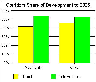
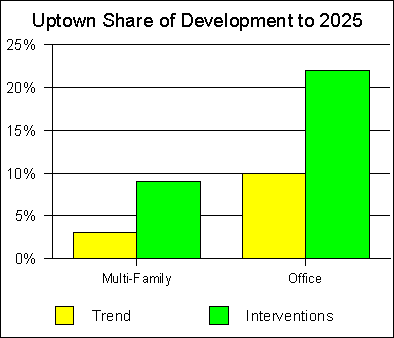
pattern…[99] As a result, the 2025 Plan notes: Making transit succeed in such a context is virtually impossible.[100] Thus, the key to transit’s anticipated role in alleviating traffic congestion is residential and employment densities at sufficient concentrations and patterns that can be served effectively by transit. Corridors and Wedges Current trends do not indicate either the density or patterns of development that are necessary to support effective transit service. As a result, the 2025 Plan seeks strategies to alter future development patterns that would be more conducive to reliance on transit. The key, according to the 2025 Plan, is to steer both residential and commercial development to the five corridors (North, University, Independence, South and Airport), and away from the “wedges” between. Moreover, it is intended the “edge cities” that are likely to develop along the new orbital freeway (I-485) should be located where these corridors intersect with the highway. At the same time, Uptown, which is the locus (hub) where the five corridors meet, would continue to experience continued growth, both in employment and residences. The vision of the 2025 Plan would be for employment and residential densities to develop in transit station areas (within one-half mile of stations) along the corridors and Uptown. The effect would be for transit oriented development to be created along each of the corridors, which it is expected, would reduce reliance on automobiles and alleviate traffic congestion Less development would occur in the wedges (outside the corridors), which would be linked to the corridors by feeder bus service. This linkage would, it is anticipated, make the five transit corridors more accessible to residents within the wedges. To accomplish this reorientation of development from the present trend to the arrangement sought by the 2025 Plan would take ”significant intervention,” as the 2025 Plan indicates. A study by the Urban Land Institute (ULI) of the South Corridor concludes that a host of incentives (tax credits, tax benefit districts, tax increment financing, public investments, density bonuses, by right zoning and the use of imminent domain to take the necessary land for prescribed developments) will be needed to realize the land use objectives of the 2025 Plan. The ULI report concludes, “Achieving that form of development, given past development trends in Charlotte, will require extraordinary efforts by both the public and private sectors.[101] Compared to the projected trend as would be dictated by the market, the following results are projected to 2025: The corridors would obtain 29 percent more of the multi-family housing units and 15 percent more of the commercial development under the 2025 Plan interventions than under the current trend (Figure #16).[102]
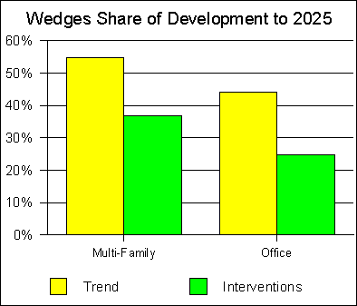
Figure 16 The wedges would obtain 33 percent less of the multi-family housing units and 43 percent less of the commercial development under the 2025 Plan interventions than under the current trend (Figure #17).[103]
Figure 17 . The center city area (largely Uptown) would obtain 200 percent more of the multi-family housing units and 120 percent more of the commercial development under the 2025 Plan interventions than under the current trend (Figure #18).[104] It is projected that Uptown employment would rise form 58,000 to 90,300 over the period.
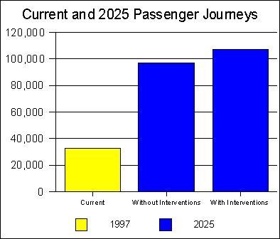
Figure 18 Along each of the corridors, higher capacity transit service would be provided. DMU rail service would operate in the North corridor, bus rapid transit in the University, Independence and Airport corridors, and light rail in the South corridor. It is anticipated by the MIS that commuters would be drawn by transit services to employment locations all along the corridors, as well as Uptown. A number of strategies would be employed to obtain the higher density land use patterns sought under the 2025 Plan. Generally, there would be incentives to develop at higher densities and with “transit friendly” designs within the corridors, especially in the vicinity of the transit stations. Property owners would be permitted to build “accessory apartments” (also known as “granny flats”) Various strategies would be employed to increase neighborhood densities. For example, “overlay” higher density zones could be established in the transit corridors. Greater administrative discretion is also proposed, which would make it possible to obtain approvals to build at higher densities without the longer processes and hearings that are now required. However, it is not clear that neighborhoods will be supportive of higher density development or more liberal zoning. Neighborhoods in more conventional urban oriented communities such as Arlington, Virginia (Washington area) and Berkeley, California (San Francisco area) have resisted attempts at densification. Transit and the Land Use Plan Implementation of the 2025 Plan is projected to result in a substantial increase in transit ridership. By 2025, daily ridership (passenger journeys, as opposed to boardings) are expected to rise to 97,400 without the planned land use interventions. With the land use interventions, ridership is projected at 106,800.[105] Either of these figures would represent an unusually large increase in ridership from the present. Without the land use interventions, ridership would nearly triple, while the land use interventions would produce ridership that is more than three times the present level (Figure #19).[106]
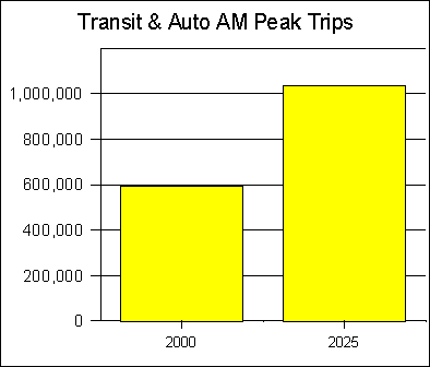
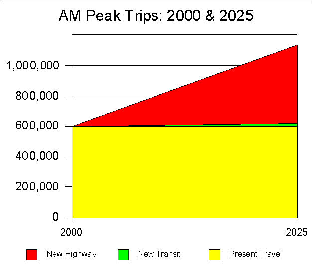
Figure 19 This ridership increase would represent an annual increase of approximately 22 million annual passenger journeys from 1997. This is approximately 50 percent above the number of new riders experienced by Atlanta’s MARTA over a 20 year period during which a six line, 40 mile rapid rail system (not light rail) was opened.[107] Moreover, Atlanta started from a ridership base at least five times that of Charlotte. It is not credible that Charlotte, with a much smaller market, with lower capacity and slower rail systems would experience a larger ridership increase than Atlanta. Moreover, according to CATS, even with the land use interventions, Uptown Charlotte will have a density of only 47,000 jobs per square mile. This is well below the 100,000 and greater densities typical of downtowns in metropolitan areas with significant transit ridership. In the United States, downtowns represent both the most important destination for discretionary transit riders (transit riders who have automobiles available for the trip) and the only location to which there is significant discretionary ridership (Appendix A Impact on Traffic Congestion An important problem is that transit, according to the projections within the very same 2025 Plan, will not reduce traffic congestion. Even if all of the land use objectives are met, and concentrated residential and employment densities arise in the five corridors, transit will have very little impact. The 2025 Plan indicates that by 2025 there will be an increase of more than 2.7 million daily person trips per day in Charlotte-Mecklenburg.[108] During the morning peak period, it is projected that the number of person trips will rise by 425,000 or more daily (Figure #20).[109] This would represent a 2000 to 2025 increase of approximately 68 percent from 2000.[110]
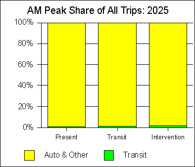
Figure 20 Transit’s overall share of trips during the morning peak in Charlotte-Mecklenburg would be 3.5 percent with the land use interventions and 3.2 percent without the interventions. In contrast, transit’s market share would be 1.8 percent with neither the transit improvements nor the land use interventions (Figure #21).[111] This is too small a shift in automobile to transit usage to be perceivable in either traffic congestion or air pollution.
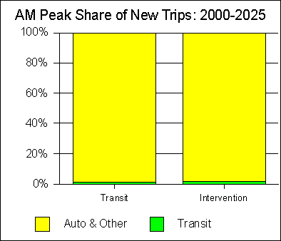
Figure 21 At the same time, transit is projected by the 2025 Plan to attract, at most, 1.7 percent of these new person trips during peak hours, if all of the land use interventions are successful. If the land use plan were not implemented, the 2025 Plan projects that transit would attract a somewhat smaller 1.3 percent of the new travel (Figure #22).[112] The land use interventions, according to the 2025 Plan, would account for a shift of than 0.4 percent from autos to transit. This is a number that is so small as to be of virtually no significance.
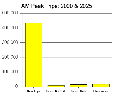
Figure 22 The insignificance of this shift from autos to transit is illustrated by the fact that, at most 15,200 daily morning peak period trips would be taken by transit, out of the more than 1,000,000 person trips, even with the full range of transit improvements and land use interventions. (Figure #23).[113] Out of the projected 425,000 or more new morning peak trips, transit would account for, at most 7,300 new trips with the land use interventions. Without the land use interventions, transit would attract 5,700 of the 425,000 new trips (Table #6). Thus the land use interventions, in themselves, would account for a 0.4 percent shift from automobiles to transit.
Figure 23
It seems safe to say that a 0.4 percent[114] transfer of new trips from autos to transit is not likely to be of sufficient impact to be perceivable. Moreover, even the 1.68 percent[115] auto to transit shift from the land use interventions and construction of the five transit corridors is not significant. Travel demand in Charlotte-Mecklenburg is projected to increase approximately 68 percent. With the transit improvements and the land use interventions, all but one percentage point of this increase would be on the roadway system (Figure #24).[116]
Figure 24 Chart enlarged to make “New Transit” more visible. Traffic and Land Use But the very land use strategies that would focus development around transit stations in the five corridors will, in itself worsen traffic congestion. Traffic and Air Pollution: For densifying land use interventions to improve air pollution and traffic congestion requires that there be a significant shift of travel from automobiles to transit and walking. While it is possible to achieve greater residential and employment balance in some centers, the modern metropolitan area is far too complex and interdependent to expect major travel changes. People who live in apartments or lofts in the central area will not only work downtown. People may do some shopping at the small local markets that would develop in transit oriented developments. As regards major shopping trips, it is likely that many shopping trips will be made by car to conventional malls, strip developments or “big box” retailers.[117] This will especially be the case among the large percentage of people for whom low prices are a requirement. Across the metropolitan area, regardless
of the density of development, employment for all but a few requires automobile
travel, as does most shopping. Moreover, the segmented nature of modern trips
(trips that combine, for example travel to employment with shopping or child
care) makes alternatives to the automobile impractical for most trips. In the
modern American urban area, increasing residential and commercial densities is
largely incompatible with reducing traffic congestion. Densification, in an affluent society,
will simply not produce enough of a transfer of travel from automobiles to
transit and walking to counteract the higher automobile demand that occurs from
having more people (and more cars) in a particular area. The evidence suggests
that there is virtually no prospect of such a change in travel behavior. This
is demonstrated by the insignificant share of new trips that are projected to
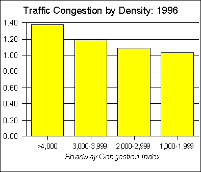
be carried by transit under the 2025 Plan (above) Higher Densities Induce Greater Traffic Congestion: Data in the United States and anecdotal information from around the world indicates that traffic congestion is worse where population densities are higher. US traffic congestion, as measured by the Roadway Congestion Index (RCI) tends to be worse as urbanized areas increase in density. In 1996, urbanized areas with population densities of less than 2,000 had an average RCI of 1.03, considerably lower than the 1.38 of urbanized areas with more than 4,000 persons per square mile (New York and Los Angeles). The RCI tends to increase exponentially as population density increases. The difference in RCI between the 1,000 to 1,999 category and the 2,000 to 2,999 category is approximately five percent. Between 2,000 to 2,999 and 3,000 to 3,999 the difference rises to nine percent, while between 3,000 to 3,999 and 4,000 and above escalates to more than 15 percent (Figure #25).[118]
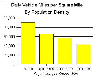
Figure 25 Moreover, traffic congestion is greater
in more dense urban areas because traffic volumes are more dense. As urban area
density increases, so does vehicle miles per square mile (Figure #26).[119]
In urban areas with population densities greater than 4,000 per square mile,
vehicle miles per square mile is more than double that of urban areas with
population densities of 1,000 to 1,999 per square mile.
Figure 26 Traffic Congestion
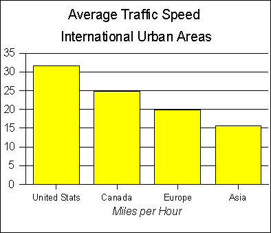
is Intractable in “Transit Oriented” Metropolitan Areas: Generally,
urban areas in Europe, Asia and Canada have higher densities than in the United
States and much higher public transit market shares. While directly comparable
international traffic congestion data is not available, it appears that traffic
congestion is considerably greater in more transit oriented urban areas , such
as London, Paris, Tokyo and Osaka. . These metropolitan areas, as in the case
of a small number of US metropolitan areas (New York and Chicago are examples)
are centrally configured in a manner that is very conducive to transit use and
walking. Yet, traffic congestion is severe. Average roadway speeds are 40
percent lower in Europe and more than 50 percent lower in Asia, where
population densities are considerably higher than in the United States (Figure
#27).[120]
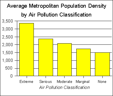
Figure 27 Higher Densities Result in Greater Air
Pollution: Where there are
higher densities, there are higher densities of travel (vehicle miles per
square mile), as noted above. In consequence, air pollution is more severe.
This is illustrated by the average density of US urbanized areas based upon
their air pollution classification, Urbanized areas rated “extreme” with
respect to air pollution had an average population density or nearly double or
more than that of urbanized areas with no air quality problem (Figure #27).[121]
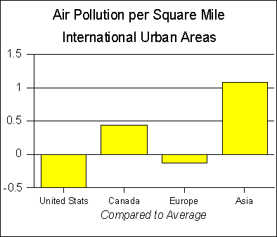
This is also illustrated by the higher intensity (pollutant production per
square mile) of air pollution in nations with higher density urban areas. Europe, with population densities four times
that of the United States, tends to have from 40 percent to 100 percent higher
pollution intensity. Asian urban areas,
more than 12 times as dense as US urban areas average three to five times US
air pollution intensity levels.[122]
Figure 28
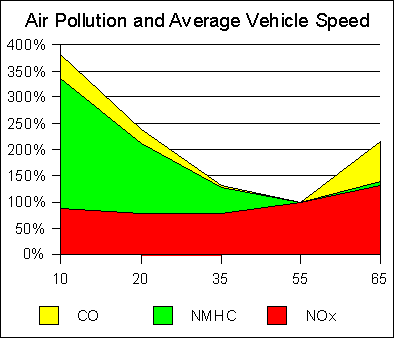
Figure 29 Slower Speeds Increase Air Pollution: The density and traffic related increase in air pollution results from more than the mere increase in traffic volumes. As traffic congestion increases, average speeds are reduced and air pollution increases. Among the two of the three primary mobile
source pollutants (CO and VOX), the optimal average operating speed is
approximately 55 miles per hour.
Average speeds of 35 miles per hour produce approximately 30 percent
more pollution, 20 miles per hour 110 percent to 140 percent more and 10 miles
per hour 335 percent to 380 percent more. With respect to the third primary mobile source pollutant,
(NOX) the optimum average speed is approximately 20 miles per hour, though 45
miles per hour produces little additional pollution. Above 45 miles per hour
NOX pollution increases more rapidly. Thus, with respect to air pollution,
optimum operating speeds is approximately 45 miles per hour. Nationally,
average work trip speeds are less than 34 miles per hour, indicating that air pollution could be
generally improved by increasing average automobile operating speeds (Figure
#28).[123]
Figure 30 Ballston: Density and Traffic: The problem is illustrated by the case of Ballston, Virginia, a transit oriented development around a Washington Metrorail station with five times the residential density of nearby single family neighborhoods. Per capita vehicle miles traveled have been reduced by 20 percent. However, because there are so many more people in a small area, overall traffic volumes are 400 percent higher than in the nearby single family communities.[124] The net effect is greater traffic congestion, which results in slower speeds, more intermittent traffic speeds and greater air pollution. It is likely that the higher traffic volumes have reduced speeds, which would mean that drivers in Ballston are spending more time per capita in their cars than drivers in the nearby communities. The key to reducing traffic congestion with higher density development to reduce average daily automobile travel per person to more than compensate for the increase in population. . Thus, for example, in Ballston, just to maintain traffic congestion and air pollution at single family neighborhood levels would require vehicle hours per capita to be reduced by 80 percent.[125] To reduce traffic congestion by 25 percent would require an 85 percent reduction in per capita vehicle hours. The 2025 Plan itself implies traffic is likely to deteriorate in the corridors, by suggesting that highway “level of service” (congestion) standards could be relaxed because of greater transit availability.[126] Relaxation of highway congestion standards means that traffic would be allowed to get worse than it would otherwise before corrective action, such as the addition of capacity, would be required. Corridors and Wedges: Making Charlotte Less Competitive It is by no means certain that the 2025 Plan land use plans will be successful. The market interventions required to obtain the land use sought by the 2025 Plan should be understood as significant. There is little doubt that, through administration of the plan, that Charlotte-Mecklenburg can discourage development where it is not desired, primarily in the wedges. But it is far more problematic to shift development that would have otherwise occurred in the wedges to Uptown and the corridors. By limiting areas for development
primarily to the corridors, Charlotte-Mecklenburg will, in effect, be “picking
winners” with respect to development. At least within Charlotte-Mecklenburg,
there will no longer be “abundant developable land in all directions”[127]
will no longer be the case. Less land will be available for development in
Charlotte-Mecklenburg. As in the case of scarcity with respect to any good,
prices tend to be driven up (all things being equal). The higher prices are
likely to be reflected not only in land costs, but in the costs of new
buildings as well, because developers will be able to charge higher prices
generally because there will be less competition. Smaller developers are likely
to be crowded out of the market, as the smaller number of larger developers is
able to charge higher prices as a result of the lessened competition. This has
already been observed in
Portland.[128] Such
regulation can lead to a situation in which governments must “pick winners”
with respect to developers, which could lead to inappropriate attempts to
influence political decisions. Because of the intense competition in the southeast region and elsewhere, such regulation is likely to reduce the rate of growth with respect to both residential[129] and commercial development. In the end, it is thus likely that the land use interventions will reduce the demand for development in Charlotte-Mecklenburg. It is thus likely that the land use interventions will drive development away from Charlotte-Mecklenburg. As the 2025 Plan notes, “adjoining counties are aggressively pursuing job growth.” Charlotte-Mecklenburg is at particular risk, as one of the nation’s most deconcentrated major metropolitan area (above). It is not just the Charlotte area counties that are aggressively pursuing job growth. Vast areas of North Carolina and South Carolina are desirable for commercial and residential development and are seeking development. Two of the most important elements infrastructure for corporate location are access to interstate highways and access to major airports. Both North Carolina and South Carolina are well served by a dense pattern of interstate highways. Many counties outside the Charlotte metropolitan area are within comparatively convenient highway travel time of Charlotte-Douglas Airport. Further, major airports are to be found to the west, north and south within approximately 100 miles or less (Greenville, Greensboro and Columbia). Generally, as a result, once a potential site becomes inconvenient to Charlotte-Douglas International Airport, it is likely to be within convenient highway travel time of one of the other three major airports. The introduction of smaller, regional jets is transforming the airline industry. Nonstop jet flights are now being offered to major markets from smaller markets, and as a result, the inherent air travel disadvantages of smaller urban areas are becoming less intense. It is not inconceivable that, as more regional jets come into service, Charlotte-Mecklenburg’s driving of development to other areas could make locations such as Fayetteville and Florence much more attractive. In short, Charlotte-Mecklenburg is in an intense competition for commercial development and can ill afford to hobble itself with land use regulations that could drive potential development to other markets. Finally, the proposed US Airways-United Airlines merger[130] could negatively impact the Charlotte area. The US Airways Charlotte hub has one of the smallest local metropolitan markets of any major airline hub in the nation. Airline hubs in metropolitan areas of similar size have generally not been sustainable. Raleigh-Durham and Nashville, for example, have both been had inconsistent histories as airline hubs. If the emerging company decides to rationalize its operations, the hub in Charlotte is a likely candidate for closure.[131] The land use interventions in Charlotte-Mecklenburg could slow development in the area, making the hub less competitive and more threatened. Even without the US Airways-United Airlines merger, any strategy that diverts growth elsewhere could threaten the long term future of the Charlotte hub. Impact on the Standard of Living The land use interventions could also reduce the local standard of living and impose inordinate costs on low income residents. Less Affordable Housing: As noted above, to the extent that there
is greater regulation of land development, there will be less competition among
developers Displacement of Low Income Residents: In short, the policies of densification could raise the cost of living for residents. Perhaps most importantly, Charlotte’s comparatively affordable housing market could become more expensive, effectively raising the economic ladder for young people and low income people (a disproportionate share of whom are minorities) seeking to purchase homes. This would be particularly disruptive in the lower income core areas. Higher densities could only be achieved through new development. This would take the form of new construction and improvement of existing structures. The result would be similar to that of the relatively small scale “gentrification” trends in the 1970s, when middle and higher income people supplanted low income people in formerly economically distressed neighborhoods. As a result, low income people are likely to be forced out of their living quarters by higher rents and higher property taxes. They would be forced to seek accommodations in suburban areas, which would have also experienced escalation of housing costs due to the land regulation that is required to achieve the densities. Another social consequence is that many displaced lower income people who would have previously used the more dense inner city transit system for employment and other trips could find little or no transit service available. This could restrict both mobility and access for low income residents, leading to lower employment rates and living standards. Higher Product Prices: To the extent that there is greater regulation of retail development, higher product prices will occur. This would also result from the higher land prices and could be exacerbated by limits on store sizes and “big box” retailers. Higher Infrastructure Costs: It is unlikely that the infrastructure system in the densifying core area will be sufficient to accommodate a substantial population increase without major improvements. As a result, regional costs for sewers, roadways and water systems are likely to be significantly increased by densification. Within the areas around transit stations, the higher land prices will be reflected in the prices of single family housing. If the plan is successful in developing transit oriented developments, lower income people are likely to be displaced as a result of rising housing prices. This could intensify economic disparities, while forcing people who rely on transit because of low income into areas with less intense transit service. Generally, it can be expected that the implementation of the land use interventions will increase the housing mobility of people in Charlotte-Mecklenburg. Many residents of radically changing neighborhoods are likely to be driven out in response to the changes. Moreover, it is not at all clear that those who move will stay in Charlotte-Mecklenburg. A recent report in the Charlotte Observer found that almost 53,000 people had moved from Mecklenburg County to the surrounding counties between 1994 and 1998. Seventy percent of Union County new residents and fifty percent of Cabarrus County new residents moved from Mecklenburg County.[132] From 1990 to 1999, more than 46 percent of the Charlotte metropolitan area population growth was outside Charlotte-Mecklenburg, a slight acceleration of the rate in the 1980s. Many residents in the low density neighborhoods that largely surround the proposed station locations could find the sharply higher densities unacceptable, and could move, most likely to outside Charlotte-Mecklenburg. No Precedent for Densification A wealth of academic and theoretical literature has been produced to suggest the potential for reforming urban areas through the use of transit and land use interventions. Often these studies compare auto-oriented US metropolitan areas to international metropolitan areas that are more transit oriented. What is usually not noted is that none of the international transit oriented metropolitan areas was planned for that objective. More importantly, virtually all metropolitan areas in the developed world (western Europe, Japan, Canada, Australia and New Zealand) are decentralizing and suburbanizing, while transit faces either stagnant or declining market shares. Virtually no urban area in the developed world has experienced a trend of significantly higher densities in recent decades.[133] In fact, there is no precedent for reallocation of urban growth in such a significant manner as is being proposed in the 2025 Plan. For example, officials in the Stockholm area have attempted to focus developments along rail corridors in recent decades, but buyers have diluted the effectiveness of such plans by demanding less dense housing patterns[134]. In the final analysis, it seems unlikely that the Charlotte-Mecklenburg land use interventions will be successful. They are likely to discourage development where not wanted, but are highly unlikely to steer that development to the favored locations. The result will be a less competitive Charlotte-Mecklenburg, in relation to suburban counties, other areas of North Carolina and South Carolina, other parts of the nation and the world. Reorienting the City for Transit The 2025 Plan’s corridors and wedges vision appears similar to the classic strategy of marketing what the producer prefers, rather than what the consumer prefers. In reviewing the 2025 Plan the impression can be easily obtained that local planners are seeking to reorient the community for the purpose of transit. If their vision was supported by believable projections to the effect that Charlotte would become substantially less dependent on automobiles and more dependent on transit, such an approach could be more defensible. But their very own projections show only insignificant market share changes. The projected changes would be slight in comparison with the land use interventions that would be undertaken. In the final analysis, the “wedge and corridor” plan could be the cause of greater traffic congestion, air pollution and higher housing prices that could work to nullify the 2025 Plan objectives of inner city competitiveness and revitalization. THE 2025 PLAN: DEAD ON
ARRIVAL Inexplicable Policies: The 2025 Plan,
which was promoted to voters on the basis of its ability to reduce traffic
congestion and air pollution would do neither even if it were deliverable.
Projections in the MIS and the 2025 Plan itself indicate impacts in the
area of one percent, after an overall
increase of 68 percent in traffic to 2025. The Charlotte area would continue to
have among the lowest rates of transit utilization in the United States.
For the few who can use the improved transit services, the 2025 Plan
will improve mobility. But for the overwhelming majority of Charlotte
residents, the 2025 Plan will make no difference.[135]
Indeed, if the “corridors and wedges” densification strategy is successful,
localized traffic congestion will be worse. 20 Percent on Transit? Moreover, there is no indication in any of the 2025 Plan related documents that CATS general manager Ron Tober ‘s vision of attracting between 15 percent and 20 percent of commuters to transit[136] has any basis in reality. Even if the optimistic ridership projections in the 2025 Plan are achieved, transit’s market share would rise to only 1.52 percent by 2025, 92 percent short of Mr. Tober’s 20 percent goal. Not even during peak travel periods would the goal be approached, with market share projections reaching only 3.5 percent. Finally, as the above analysis has shown, there appears to be insufficient funds to complete the 2025 Plan¸ making it highly unlikely that even these modest transit market share figures can be achieved by 2025. Even in the New York metropolitan area, transit’s market share is barely onethird of the 20 percent objective.[137] Market shares of 20 percent are typical of large European urban areas, where population densities are seven times greater than that of the Charlotte urbanized area, and concentration of work destinations in the central area is greater. The enunciation of such an objective is absurd and would seem to suggest an unfamiliarity with the data. In contrast, however,
there is a often a presumption that transit is capable of making a significant
contribution to reducing present traffic congestion or its future growth. The
reality is much more modest. (Appendix A, “Transit’s Potential: Perception and
Reality”). In view of the minuscule impact of the expensive
transit improvements on transit usage, traffic volumes and air pollution, the
2025 Plan’s emphasis on transit is inexplicable. This is not just a
theoretical problem. The considerable resources being committed to transit could
be used more effectively to solve Charlotte’s transportation problems. What is
needed is pragmatism and realism, not approaches based upon theories that
produce results not even the planning models can be manipulated to make
significant. A Report Card: It is clear that the 2025 Plan as submitted to and approved by the voters cannot be delivered in its present form without substantial additional revenues. Based upon trends from 1998 to fiscal year 2001 and national rail construction cost trends, the 2025 Plan, which was to have cost $1.085 billion appears to have escalated by more than 150 percent to nearly $2.9 billion. The 2025 Plan appears to be at nearly a $1.8 billion deficit (all figures 1998$).
The 2025 Plan may effectively be “dead on arrival.” As noted above, the 2025 Plan may still feasible if all corridors are developed as bus rapid transit lines, and bus service is converted to competitive contracting. But it is clear that the rail lines promised simply cannot be delivered without gutting the program’s other corridors and/or bus service expansion. The 2025 Plan is effectively out of control from a financial perspective and does not appear to be driving transit decision making. CATS now indicates that major elements (design and
construction management) were left out of the plan. CATS is producing operating cost projections that far exceed
those contained in the 2025 Plan. Capital costs are rising quickly and it appears unlikely
that some of the promised transit corridors will not be built, especially the
Bus Rapid Transit corridors to east Charlotte and west Charlotte An effort is underway to add a “temporary” commuter rail
line in the North Corridor, that was not in the 2025 Plan. This
financial requirements of this project, not included in the 2025 Plan,
could place further burdens on the already in-trouble transit financial plan. It seems fair to suggest that the current condition and administration of the 2025 Plan represents a breach of faith with the electorate. It seems fair to suggest that the current condition and administration of the 2025 Plan represents a breach of faith with the electorate. At a minimum, Charlotte-Mecklenburg should undertake an immediate and independent review to assess and project performance relative to the plan and undertake such an analysis each year. This would be similar to the Congressional requirement for a “cost to complete” report which was issued every two years during construction of the interstate highway system. If, as this analysis concludes, the 2025 Plan cannot be delivered within the constraints and assumptions of the 2025 Plan, action should be taken to suspend further expenditures and further financial obligations until a new and defensible program can be placed before the voters for approval. . APPENDIX A: TRANSIT’S POTENTIAL: PERCEPTION AND REALITY The modern urban area faces a dilemma in transportation. There is what might be called a “blind faith” that transit is the antidote to urban traffic congestion. In reality, however, this view is largely false and leads to unrealistic expectations of transit. There is a recognition that the suburbanized urban form that has emerged in the 20th century has been associated with much greater automobile use. From a theoretical perspective, the answer seems clear to some --- reduce automobile usage, which would require significant substitution of trips by transit, walking and cycling. Part of this perception may be due to the fact that so many people now visit environments in which transit works very well as an alternative to the automobile. For example, transit, and especially heavy rail systems (subways and elevated), provides for a significant share of travel in the city of New York, central London, the city of Paris, the city of Tokyo and Hong Kong. Such central cities tend to have very large central business districts (some with more than one million jobs), and residential densities are very high. For example, the city of Paris has approximately one million jobs within its 40 square miles and a residential population density of more than 50,000 per square mile. In an area little larger than Paris, Hong Kong has more than one million jobs and a population density of nearly 100,000 per square mile. Hong Kong’s central business district has an employment density of nearly 450,000 per square mile, nearly double that of New York. The central cities of New York and Tokyo both have approximately two million jobs in their central business districts, and population densities of at least 25,000. Such environments make for successful rail systems (for a description of “rail successes, see Internet: www.publicpurpose.com/utx-rails.htm). But such cities are the exception, rather than the rule. Even so, with the exception of Hong Kong, the suburbs of each of these highly transit dependent central cities are highly automobile dependent. Most tourists, however, rarely venture for any period of time into the suburbs of such cities, and may tend to perceive that all of the urban area looks like the center. The city of New York represents the only highly transit dependent environment in either the United States or Canada. Because modern metropolitan areas are so expansive, reducing automobile use is no simple matter. In the modern urban area, destinations are far apart and dispersed throughout a geographical expanse that cannot be competitively served by transit and makes walking and cycling either infeasible or unattractive for the overwhelming majority of trips. While densification strategies may, at the micro (personal) level allow for some reduction of automobile use for a few, the overwhelming majority of trips even in the denser areas will be by automobile. At the macro (community or regional) level, little, if any change in travel behavior will be observed, and traffic will continue to get worse. Achieving a significant increase in transit market share: It may be impossible, under any set of circumstances, to increase Charlotte’s transit market share to a level that would make a perceivable difference. This is illustrated by the levels of transit service that are necessary to support much greater transit market shares in European and Asian urban areas. Large European urban areas provide transit service levels per square mile that are more than 20 times that of Charlotte (adjusted to account for differences in population density). The Captive Market: The captive market includes transit passengers that do not have an automobile available for their trip. This is, by far, transit’s largest market segment, constituting 70 percent of transit ridership.
Low income people are far more likely to not have automobiles available for their trips. As a result, they may be captive to transit for their mobility Transit provides effective access, primarily within the central city, for people without access to automobiles. Transit also provides access for central city residents to some suburban employment centers. In general, however, transit is unable to provide access to suburban jobs that are dispersed throughout the urban area. One of the nation’s most intractable problem is the persistence of poverty. Employment is crucial to the reduction of poverty. Yet many low income citizens live in inner city areas where there is little job growth. At the same time, there is rapid job growth in the suburbs, but suburban jobs are inaccessible because many low income people do not have cars and because such locations are often beyond the reach of transit service. This creates a “reverse commute” problem. A federal report, for example, found that only 14 percent of the employment in suburban Boston locations is accessible to central city low income resident by less than a one-hour transit ride.[138] The Boston area has one of nation’s highest levels of transit service. The “captive” market: Disabled access throughout the service area: People unable to use conventional bus and rail service by virtue of disability are provided with door-to-door service, pursuant to federal requirements. This service provides alternative access throughout the service area. The Discretionary Market: The discretionary market includes people who have automobiles available for their trip, but take transit instead.[139] With respect to the discretionary market (people who have automobiles available), transit’s potential is much more limited. Discretionary Market: Downtown work trips: Transit provides an alternative to the automobile for downtown commuters. In the United States, downtown is the only location in the urban area to which transit provides service that is time competitive with the automobile. For all practical purposes, therefore, downtown represents the only destination to which transit is attractive to people who have automobiles available. This is because so much transit service is oriented toward downtown as a hub. Downtown justifies high levels of service because in virtually every major metropolitan area with significant transit ridership, downtown contains a large number of jobs and at a density much greater than that of any other area. Discretionary market: Non-downtown work trips: Suburban employment centers and other non-downtown employment locations, even when comparatively densely developed, tend to be particularly pedestrian unfriendly, with buildings spaced far apart and often without sidewalks. Pedestrian “friendliness” is important to public transit, because its riders walk to their places of employment from transit stops. Suburban (non-downtown) employment centers generally do not have automobile competitive transit service, virtue of the fact that travel times are excessively long. This is because most suburban work trips would require travel to downtown and transferring to another bus or train. The dilemma for the potential non-downtown transit commuter is similar to what occurs in the airline hub and spoke system. A person seeking to fly from Washington to Cleveland could fly on US Airways from Washington to Charlotte and then transfer to a flight to Cleveland. This indirect and time consuming itinerary, however, is not likely to appeal to the majority of travelers. Unless there is no choice, or there is a significant cost difference, the Washington to Cleveland air traveler will take the direct flight rather than the itinerary that requires a transfer (change of plane). As a result, throughout the nation, even densely developed suburban employment centers have comparatively low transit work trip market shares. Discretionary Market: Other Trips: Generally transit service to non-work destinations is far too slow and inconvenient in comparison with automobile travel. An exception is travel to sporting and other special events in the downtown area, where there is some transit use by people who have access to automobiles.
APPENDIX B: TABLES
[1] p iii. [2] p iii. [3] “He Aims to Smooth the Ride,” Charlotte Observer, January 2, 2000. [4] Internet: www.ut-usptshare45.htm. From 1995 to 1997, transit’s urban market share has risen from 1.77 percent to 1.83 percent. [5] US Census Bureau data. [6] 1995 Nationwide Personal Transportation Survey, United States Department of Transportation. [7] ###need a footnote. [8] US Census Bureau data. [9] Some light rail systems include significant sections of grade separation. [10] Calculated from US Department of Transportation Federal Transit Administration National Transit Database (NTDB) and San Diego Metropolitan Transit Development Board data. [11] Some cities have established what might be characterized as “nostalgic” light rail lines, which normally provide downtown circulation or trips to tourist attractions (such as Seattle, Galveston, and Memphis). These lines perform virtually the same function as downtown circulator bus routes, such as in Los Angeles, San Antonio and Denver, but at considerably higher cost. The San Antonio downtown bus circulator system can also be considered “nostalgic,” since it uses buses designed to resemble light rail vehicles. [12] Data from transit agencies. [13] Express buses generally operate faster than light rail. [14] Calculated from National Transit Database. [15] Internet: www.publicpurpose.com/-97ptus49.htm. [16] Internet: www.demographia.com/db-met99.htm. [17] Mecklenburg, Gaston, Cabarrus, Lincoln, Rowan and Union counties in North Carolina and York county in South Carolina. [18] Comparisons of metropolitan area densities can be misleading due to their definition on the basis of county boundaries, which vary greatly in size. Metropolitan areas with larger counties tend to have a larger percentage of their area in non-urban uses. North Carolina counties tend to be comparatively small, averaging less than 500 square miles. By comparison, San Bernardino County (the nation’s largest), in the Los Angeles metropolitan area, covers 20,000 square miles, so large that the entire state of North Carolina could accommodate only 2.8 counties of such size. [19] Connecticut, Maryland, Massachusetts, New Jersey and Rhode Island. [20] An exception is the six New England states, where municipal boundaries are used. [21] For example, the five counties of the Los Angeles consolidated metropolitan area cover more than 35,000 square miles, more than two-thirds the size of the state of North Caolina. All of the 1990 urban development, (more than 13,000,000 population) however could be readily fit into an area smaller than seven county Charlotte metropolitan area. [22] Urbanized area data is compiled every ten years as a part of the US Census. Interim estimates are provided through Federal Highway Administration programs, but are subject to considerable variation and not considered sufficiently reliable. [23] The core urbanized area is the urbanized area containing the metropolitan area’s principal city. [24] Raleigh-Durham, which has achieved 1,000,000 population since 1990, had a core urbanized area to metropolitan area population ratio of 35.6 percent, lower than Charlotte but higher than Greensboro-Winston-Salem-High Point. [25] Calculated from US Census Bureau data. [26] Estimated from US Census Bureau data and CATS New Starts Report data. [27] Calculated from 1990 Census Bureau data. [28] The Texas Transportation Institute-Federal Highway Administration Roadway Congestion Index measures the comparison of traffic levels to highway capacity in urbanized areas. A score of below 1.00 indicates excess capacity, while a score above 1.00 indicates demand that is greater than capacity. [29] Metropolitan area. [30] Journey-to-Work Trends in the United States and its Major Metropolitan Areas: 1960 to 1990, US Department of Transportation, Federal Highway Administration, 1993. [31] US Census Bureau data. [32] Calculated from data in Journey-to-Work Trends in the United States and its Major Metropolitan Areas: 1960 to 1990. [33] US Census Bureau 1990 data (latest available). [34] US Census Bureau data. [35] As noted above, light rail generally operates considerably slower than the rapid transit modes of subways, elevated, railways and busways. Rapid transit operates in a grade separated mode, with no surface roadway or rail crossings. Most light rail lines have multiple grade crossings and some on-street operation, which makes it necessary to operate at slower speeds. As a result, light rail of the form being considered in Charlotte is not considered rapid transit. [36] 2025
Plan. [37] Generally, transit planners assume that one-quarter mile is the maximum walking distance to access transit. The planning process in Charlotte uses a broader standard. [38] Charlotte Area Transit System, South Corridor Major Investment Study (MIS), February 2000. [39] MIS [40] The No Build Alternative assumes that the other four corridors have been built. [41] There are two ridership indicators in transit. A passenger journey or passenger trip counts as one a trip by a passenger from the passenger’s origin to the passenger’s destination. The second indicator is “boardings,” which counts each time the passenger enters a transit vehicle. A passenger transferring from one bus to another thus counts as two boardings. The standard ridership indicator for the National Transit Database is “boardings,” which tends to overstate the extent of transit usage because transfers on the same trip are counted. [42] Wendell Cox, “Coping with Traffic Congestion,” A Guide to Smart Growth: Shattering Myths, Providing Solutions (Heritage Foundation and Political Economy Research Center), 2000. [43] Similar implausible results are projected for the TSM Alternative and the Bus Rapid Transit Alternative. [44] MIS. [45] MIS. [46] Based upon information provided by the General Manager of the Charlotte Area Transit System. The total capital cost is now projected at $331.1 million, including the $254 million projected in the MIS , $26.5 additional in engineering and design costs, $13.6 million in project management and a 10 percent construction contingency of $21.0 million (this is in addition to the 30 percent contingency included in the 2025 Plan figure). This calculates to the $315.1 million total. An additional $16.0 million in inflation to the mid point of construction takes the figure to $331.1 million. [47] Ron Tober, quoted in “Training the Public,” Realtor Reflections, August 2000. [48] 2025 Plan, section D.4, page D-55. [49] MIS , section 5.2.4, page 5-31. [50] This oversight could raise overall 2025 Plan costs by $200 million or more. [51] Internet: www.publicpurpose.com/ut-lrt2001+.htm. [52] The average of all light rail projects in planning is $68.7 million per mile. [53] Internet: www.publicpurpose.com/ut-lrt2001+.htm. [54] Realtor
Reflections. [55] 2025 Plan, MIS and costs based upon national average of similar projects in the FTA planning process in 2000. [56] Mette K. Skamris and Bent Flyvbjerg, “Accuracy of Traffic Forecasts and Cost Estimates on Large Transportation Projects,” Transportation Research Record (Washington, DC: Transportation Research Board, National Research Council), 1996. [57] Urban Rail Transit Projects: Forecast Versus Actual Ridership and Costs (US Department of Transportation, 1989). [58] 2025
Plan and MIS. [59] Assumes operations commence in 2005. [60] Document dated March 2000. [61] Cost per new one-way ride times 450 (assumes two commutes daily, 225 days per year). [62] Estimated
from data in MIS. 2020-2025 traffic levels extrapolated from trend to
2025. Light rail passenger miles estimated from data in the 2025 Plan. [63] Data from CATS New Starts Report, 2000. [64]S. M. Edner, G. B. Arrington, Jr., Urban Decision Making for Transportation Investment: Portland’s Light Rail Transit Line, (Washington: US Department of Transportation), 1985, as summarized in Peter Newman and Jeffrey Kenworthy, Cities and Automobile Dependence: An International Sourcebook, (Aldershot, UK: Gower Technical), 1991. [65]Calculated from Texas Transportation Institute data. [66]Erick Ferguson, “Office Development, Parking Management and Travel Behavior: The Case of Midtown Atlanta,” Journal of Transportation and Statistics, May 1999. [67]“Transit Oriented Development (TOD): Vision and Reality,” Innovation Briefs, May-June 1999. [68]In 1996, Washington had the second highest Roadway Congestion Index and Atlanta had the seventh highest. [69] Bernard L. Weinstein and Terry L Clower, “The Initial Economic Impacts of the DART LRT System,” April 1999. [70] Internet: www.tppf.org/news/pr050300.html. [71] Moshe Ben-Akiva and Takayuki Morikawa, Ridership Attraction of Rail Compared with Bus Urban Mass Transportation Administration, December 1991. [72] Calculated from projects in the Federal Transit Administration planning process in 2000. [73] Thomas A. Rubin, “The Future of Mass Transit in the United States,” Veritas, Summer 2000. [74] In “Choosing the Wrong Technology: Or How to Spend Billions and Reduce Transit Use,” John Kain describes planning processes that appear to have “preselect” rail over bus alternatives.. [75] A DMU train is powered by a diesel motors in passenger rail cars. This technology is used extensively in Europe and Japan, but not in the United States. [76] Calculated based upon DMU projects in the FTA planning process, 2000. [77] MTC Agenda August 23, 2000 meeting. [78] Capital cost per mile of all new commuter rail lines opened in the late 1980s and 1990s adjusted to 2000$.. [79] More than $1 billion in year of expenditure dollars. [80] Assumes the North Rail line operates from 2010. [81] 1979 was the first year of the National Transit Database. 1998 is the last year reported as of this time. [82] 1998$. [83] Calculated from information provided by the city of Charlotte. [84] Assumes no cost escalation from 2010 to 2025 and assumes additional operating costs for two bus transit corridors with operations averaging 10 years. [85] Calculated from London Transport Annual Reports. [86] Transportation Research Board, Transit Cooperative Research Program, Research Results Digest, May 1998 --- Number 27. [87] Calculated from Storstockholmslokaltraffic Annual Reports. [88]Internet: www.publicpurpose.com/t5.htm. [89] The Cobb County transit system is competitively contracted. [90] Calculated from National Transit Database and San Diego Metropolitan Transit Development Board information. [91] Calculated from National Transit Database. [92] Assumes a gradual reduction in operating cost per vehicle hour to the 1998 Las Vegas rate of $36.89 (1998$).. [93] Similar, though less intense trends are occurring in metropolitan areas throughout the developed world. [94] An “edge city” is a suburban business district similar in size to a downtown area. Generally, edge cities have high rise buildings but have far lower densities than downtown areas, because buildings are spaced much farther apart. Edge cities have generally developed since the 1960s. [95] 2025 Plan, page 2. [96] 2025 Plan, page 3. [97] 2025 Plan, page 2. [98] 2025 Plan, page 3. [99] 2025 Plan, page 4. [100] 2025 Plan, page 4. [101] Urban Land Institute. Charlotte, NC South Corridor Report, August 25, 2000 [102]
2025 Plan. [103]
2025 Plan. [104]
2025 Plan. [105] 2025 Plan. The MIS projects a lower ridership level with land use interventions, at 101,200 and 90,000 without land use interventions. [106] In 1997, daily boardings were approximately 42,500. At the national average transfer rate, this would convert to approximately 33,000 daily passenger trips. The 2025 Plan has used “boardings” and “unlinked trips” or “passenger journeys” inconsistently. For example, the 2025 Plan projects a daily unlinked trips figure of 106,800. The MIS and the New Starts Report project a somewhat smaller lower 101,800 unlinked trips figure (above). However the New Starts Report also places the passenger boardings figure at the same 101,800. It is not plausible that the boarding and unlinked trips will be identical (this would mean that there will be no transfers between buses or between bus and light rail). [107] From1979 to 1999, MARTA’s bus and rail passenger journeys increased from 63.0 million to 77.7 million annually. Data from MARTA. [108] Caculated from data in 2025 Plan, Appendix C-1. [109]
2025 Plan. [110] Estimated from 2025 Plan data. [111]
Calculated from data in the 2025 Plan. [112]
Calculated from data in the 2025 Plan. [113]
Calculated from data in the 2025 Plan. [114] 0.16 percent of all morning peak trips. [115] 0.74 percent of all morning peak trips. [116]
2025 Plan. [117] Contrary to what may be a popular perception, planners generally assume that big box retailers and shopping malls generate fewer automobile trips per square foot of retail space than smaller stores.This is because these retail establishments have so much more product variety, which makes it possible for shoppers to make fewer automobile trips. [118] Calculated from FHWA data for urbanized areas with more than one million residents. [119] Calculated from FHWA data for urbanized areas with more than one million residents. [120] Internet: www.publicpurpose.com/ut-intlsp&densave.htm [121] Randal O’Toole, “Dense Thinking,” Reason, January 1999, based upon US Environmental Protection Agency data. [122] Internet: www.demographia.com/db-intlpollut-aveton.htm [123] Calculated from US EPA data. [124] “Transit Oriented Development (TOD): Vision and Reality,” Innovation Briefs, May-June 1999. [125] Calculation: For single family residence area traffic level: 100%/500% = 20%. Change from current: 100% - 20% = 80%. [126] 2025 Plan, page 16. [127] 2025 Plan, page 2. [128] Some analysts have attempted to show that Portland’s rising housing costs are simply the result of its being a more attractive urban area --- that the rising costs are the result of high demand for housing by people moving into the area. Yet urban areas that have higher growth rates, such as Atlanta and Phoenix and areas that have sustained virtually the same growth rate (Charlotte and Denver). [129] Charlotte has generally experienced slightly below average housing affordability (housing price to median income ratio) in the 1990s. This is in contrast to Portland, where land use interventions have converted the market from one of average affordability in 1990 to the most unaffordable major metropolitan area outside California by 1998. [130] It is unclear whether the proposed merger will be completed at this time (May 2000). [131] At this time, United Airlines is proposing that all present routes would be served under by the new company. While such a commitment would provide some guarantee, no airline can commit to maintain a route or a hub for more than a few years. [132] Charlotte Observer article “New people may be … from here” July 15, 2000 [133] Internet: www.demographia.com/db-intlcitylossr.htm. [134]Sir Peter Hall’s Cities
in Civilization describes the resistance of Stockholm area residents to
planning dictates that required higher housing densities. In recent years, most
new housing has been, as in US suburbs, single family detached (New York:
Pantheon, 1998). [135] The extent to which the 2025 Plan funding could be used on alternatives to reduce traffic is not addressed in this report. [136] This market share is achieved only in the New York metropolitan area in the United States. [137] The 1990 Nationwide Personal Transportation Survey placed the New York metropolitan transit market share at 7.67 percent. [138] US Department of Transportation, Welfare Reform and Access to Jobs in Boston, January 1998. [139] This is not fundamentally a matter of choice. For all but a small minority of trips, transit services are either not available or are so slow as to be an unacceptable alternative to the automobile.
| |||||||||||||||||||||||||||||||||||||||||||||||||||||||||||||||||||||||||||||||||||||||||||||||||||||||||||||||||||||||||||||||||||||||||||||||||||||||||||||||||||||||||||||||||||||||||||||||||||||||||||||||||||||||||||||||||||||||||||||||||||||||||||||||||||||||||||||||||||||||||||||||||||||||||||||||||||||||||||||||||||||||||||||||||||||||||||||||||||||||||||||||||||||||||||||||||||||||||||||||||||||||||||||||||||||||||||||||||||||||||||||||||||||||||||||||||||||||||||||||||||||||||||||||||||||||||||||||||||||||||||||||||||||||||||||||||||||||||||||||||||||||||||||||||||||||||||||||||||||||||||||||||||||||||||||||||||||||||||||||||||||||||||||||||||||||||||||||||||||||||||||||||||||||||||||||||||||||||||||||||||||||||||||||||||||||||||||||||||||||||||||||||||||||||||||||||||||||||||||||||||||||||||||||||||||||||||||||||||||||||||||||||||||||||||||||||||||||||||||||||||||||||||||||||||||||||||||||||||||||||||||||||||||||||||||||||||||||||||||||||||||||||||||||||||||||||||||||||||||||